An Awakening Hike
Ḵuu Jad TlldaG̱aawa Sea Otter Woman Mountain
22 September 2022
Length: ~5km return
Difficulty: Moderate/Challenging
Timing: ~ 4 hours return
Know before you go:
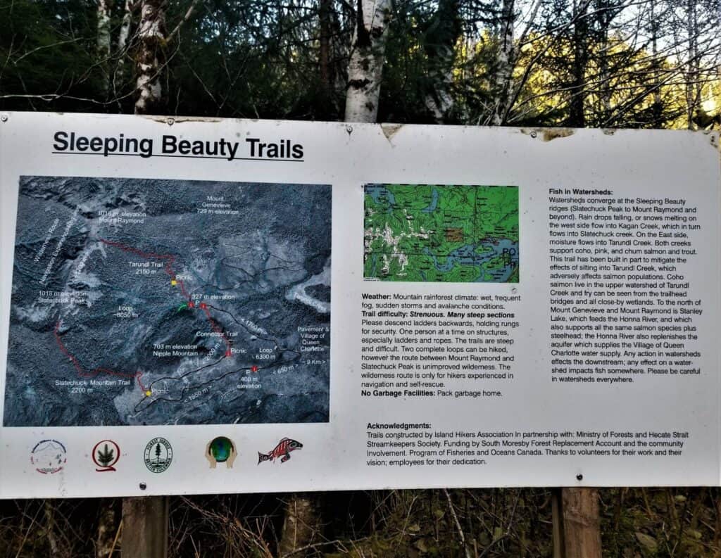
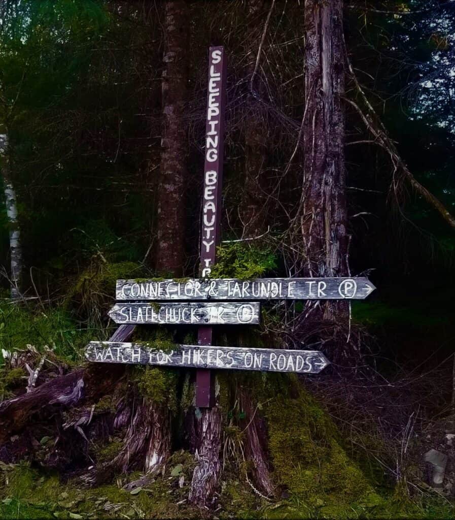
The Sleeping Beauty Trails are actually two separate trails that can be linked at the top via a ridgewalk between Mt. Slatechuck and Mt. Raymond. Some locals and online resources refer to Mt. Genevieve as the Sleeping Beauty Trail, which is wrong, and has led to much confusion. It is locally accepted that when someone says that they are “going to climb Sleeping Beauty” they are referring to the one way up and down climb up the Tarundl Trail to the Summit of Mt. Raymond. This article focuses on this hike.
There is a decommissioned trail that begins in the same area as the Tarundl Trail. To add to the confusion, about 1km before the parking area to the Tarundl Trail, there is another sign labeled “Sleeping Beauty Trails”, found at the trailhead to the Slatechuck Trail. Be sure to consult the map posted in the parking lot, and follow signage carefully to ensure you are in the right place. Many people have been led astray by this first sign.
The Tarundl Trailhead is located about 10kms down a fairly rough and steep dirt road filled with potholes. Be sure to have a suitable vehicle to navigate this terrain safely.
Cell service is available for most of the hike.
Gear and Clothing Suggestions:
Although a relatively short hike, environmental conditions can change drastically with both elevation and unpredictable weather. Pack accordingly.
Wear or bring layers of wool or poly fabric materials. Try to avoid cotton clothing.
This trail gains elevation quickly, so bring along warmer layers to deal with cooler temperatures at the top of the mountain, no matter the time of year. By mid-October until Mid-March, the mountain is usually covered with snow. Warm, high topped boots are recommended. Bring along a pair of gloves or mitts, and even a pair of small snowshoes with built in crampons for the path to the summit during snowy months.
A long sleeved shirt, comfortable hiking pants, wool socks, a rain jacket, and a light insulating jacket or pullover (made of fleece, down, or primaloft) should be your go-to clothing for the trail during any season.
Bring enough water (minimum 2L). There is a fresh creek at the beginning of the trail, and a small lake near the top of Mt. Raymond. These are not sanctioned potable water sources and should only be considered in an emergency.
Always bring a headlamp or other light source on the trail. A multitool is a wonderful addition to your day pack for various applications.
Don’t forget nutritious snacks and beverages for the summit!
GETTING THERE
From Daajing Giids (Queen Charlotte), head west on Oceanview Drive. Past the last commercial buildings, the pavement turns to gravel. Follow Oceanview Dr. past Haydn Turner campground to a fork in the road. There are signs indicating the Sleeping Beauty Trailhead is 9.2kms away, as you turn off (right) onto Honna Rd. You will remain on Honna Rd., which will take you past the Kagan Bay Recreation Site. About 500 meters past Kagan Bay, follow signs to Sleeping Beauty, indicating a right hand turn up the Honna Forest Service Rd. At this point, the road gradually climbs upwards, is steep in some locations and is pocked with pot holes. The climb will take you up past a first parking area where you will see a sign for “Sleeping Beauty Trails”. This first sign is the Trailhead to Slatechuck Mt. Trail. Keep driving past this sign about 1km to the 2nd parking area which also touts a similar “Sleeping Beauty Trails” sign, at the end of the road. This is the trailhead to the Tarundl Trail/Mt.Raymond which is what most locals refer to as “Sleeping Beauty”.
A gorgeous sunny Saturday in mid-October coaxed our group of five adventurous gals and one dog to set off in a 15 passenger van from Port Clements to Daajing Giids (Queen Charlotte) for a day trip. Our group ranged in age from 6 to 37, and our goal was to hike the Sleeping Beauty Trail.
Armed with road snacks from the Bayview Market, and after picking up some fresh local goods in the form of carrots and hummus at the Queen Charlotte Farmers market, we headed for the newly dusted snowy peaks of the Queen Charlotte Mountain Range.
The Tarundl Trail takes hikers to the summit of Mt.Raymond that, at 1018 meters, towers above the village of Queen Charlotte. The mountain is flanked by several others that take on the shape of a head and bust in a state of repose. Mt. Raymond is the “nose” of Sleeping Beauty as viewed from the town. Many a hiker, unfamiliar with the colloquial reference to the Tarundl Trail described as the Sleeping Beauty Trail, have been led astray and climbed Mt. Slatechuck instead. Others yet, having consulted some online resource, believe that Mt. Genevieve is the Sleeping Beauty Trail, however that is erroneous information. It is generally accepted by locals that the Sleeping Beauty trail is actually the straightforward hike to the summit of Mt. Raymond, which was our group’s focus for the day.
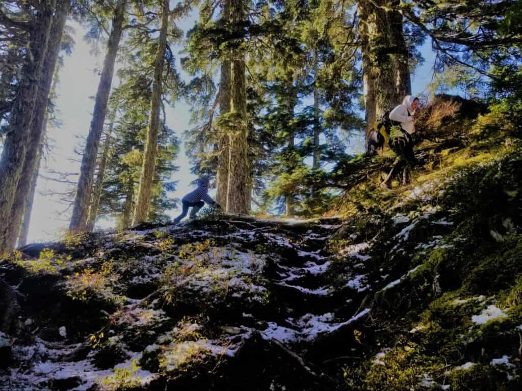
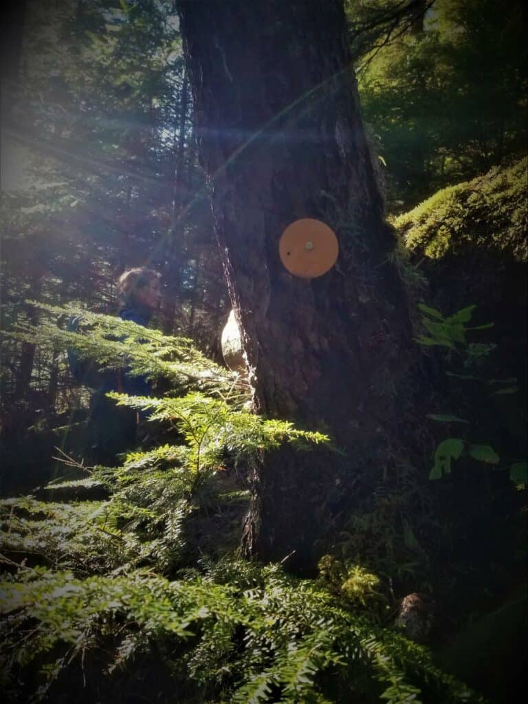
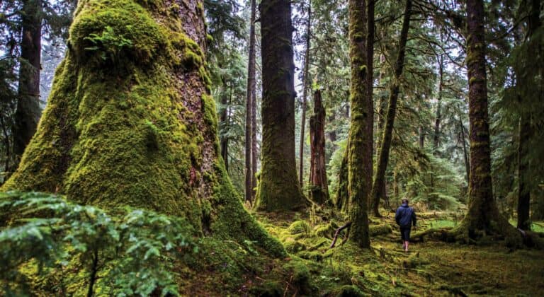
Crossing Tarundl Creek over a small footbridge signals the beginning of the trail. The path is well worn, and marked by yellow circular tabs nailed to trees, and wastes no time in ascending.
Getting accustomed to wearing their daypacks containing their spare clothing and water, the kids called the shots for rest stops. We took a few short breaks before stopping for water at the lookout and picnic area. From there, the trail continues to wind through rooty sections on a well worn path with a few built up features, including roughed in timber stairs and ropes.
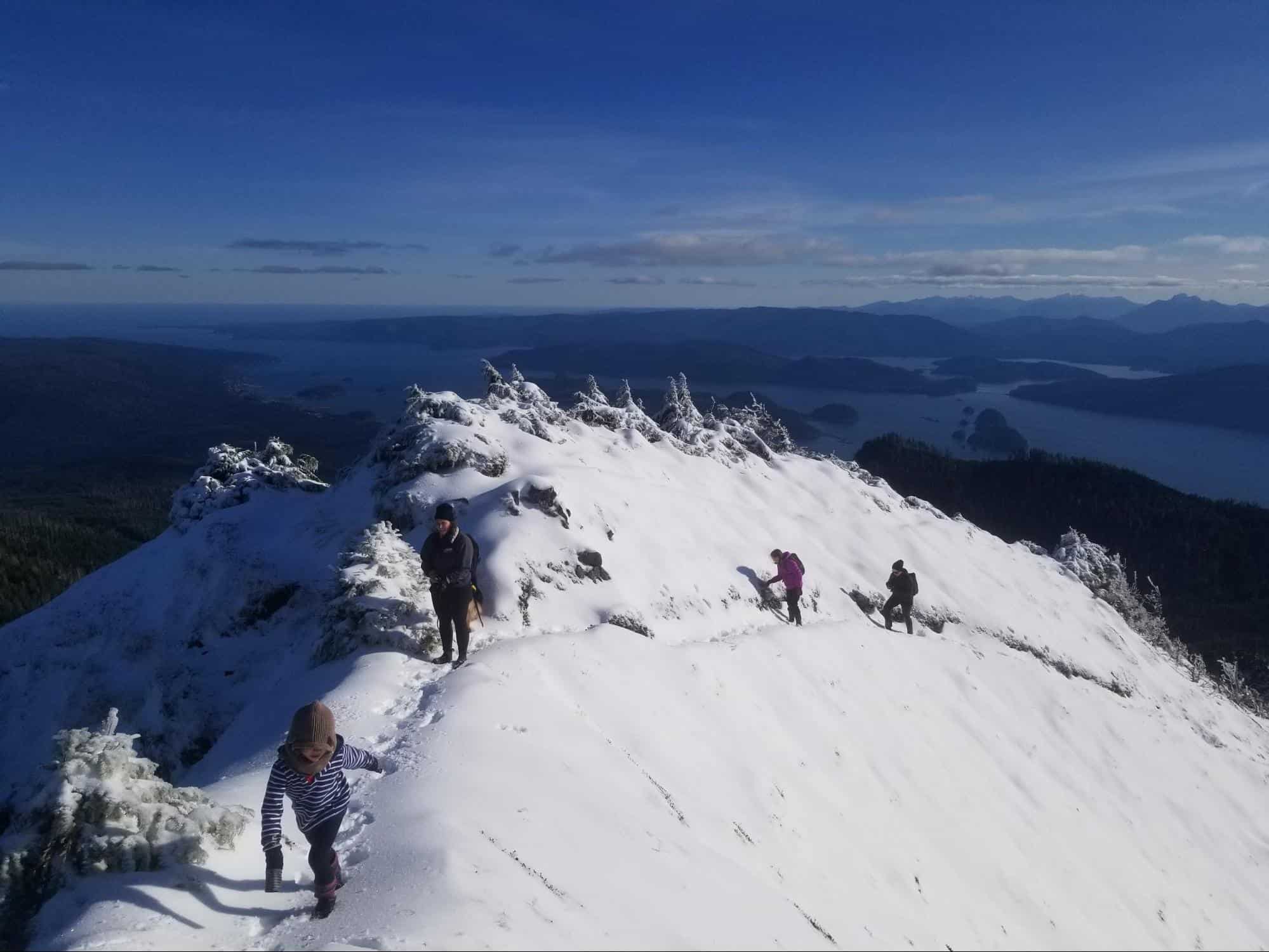
About half way up, we crossed the snow line. Although the trail goes decidedly up, it is a fairly gradual climb, and the snow did not present any traction issues. In about an hour and half, the trees became more gnarled and spaced out as we ascended into the alpine and our snowy path opened up into a large flattened area, signalling that we had reached the base of “the bowl”, which is the last push up to the summit. Here, you will find a small lake and a wonderfully open, sunny area, that offers a view of the ocean, and Daajing Giids below. The hike to this point is very achievable for most individuals with no mobility issues, including young children, and is a worthwhile effort, even if you don’t plan to make the push to the top.
The summit, although a mere extra 15 minute push, requires a little more stamina and ability, as the trail steepens significantly at this point. A couple of slippery footholds and lack of good tread on the kids’ boots made for a challenging ascent of the steepest part of the trail. But with a few encouraging words and demonstrations of the zigzag snow climbing technique by the senior members of our group, we all made it up.
Greeted by an air acrobatics display by the resident population of mountain top ravens, we basked in the glory of the three hundred and sixty degree views at the summit of Mt. Raymond – our reward for our perseverance. On this day, the visibility was crystal clear, affording views of Rennel Sound to the West, Sandspit and the Coast Mountains to the East, the Queen Charlotte Mountains to the South, and even Tow Hill to the North! This is a classic hike that offers a lot of bang for its buck and is ultimately a wonderful way to spend a sunny afternoon.
Read more about adventuring on Haida Gwaii
-

An Awakening Hike
Length: ~5km returnDifficulty: Moderate/ChallengingTiming: ~ 4 hours return Know before you go: The Sleeping Beauty Trails are actually two separate trails…
-
Cape Fife in a Day
Length: ~5km returnDifficulty: Moderate/ChallengingTiming: ~ 4 hours return Know before you go: The Sleeping Beauty Trails are actually two separate trails…
-
Into the woods
Length: ~5km returnDifficulty: Moderate/ChallengingTiming: ~ 4 hours return Know before you go: The Sleeping Beauty Trails are actually two separate trails…
