Cape Fife in a Day
22 September 2022
Length: ~10km one way
Difficulty: Moderate
Timing: ~ 3 hours one way
Know before you go:
Water sources are sparse on the way to Cape Fife. At that, those water sources are generally stagnant bog water. There are rain water barrels that collect water from the Cape Fife Shelter, although it is not treated and meant for emergency purposes or for uses other than consumption.
There is a wonderful shelter at Cape Fife with 4 bunks, a wood-stove, some emergency supplies, and a nearby outhouse. However, at this time, due to COVID 19 restrictions, the cabin is off limits to overnight guests. If you plan on staying overnight, you will need to bring your own tent and appropriate gear.
There is intermittent cell service available at a few locations near the beach east of the Cape Fife cabin.
There is an option to continue up East Beach towards Rose Spit (~7kms) and then back to the Hiellen River via North Beach (~12kms), which will take another 1 to 2 days for the average hiker.
If you are hiking alone, always tell someone where you are going and when you plan to be back.
Gear and Clothing Suggestions:
Be prepared and wear layers. Breathable, yet insulating fabrics such as wool or poly blended tops and bottoms are the best fabrics for the environment. Cotton anything is not recommended.
A long sleeve shirt, comfortable hiking pants, wool socks, sturdy waterproof hiking boots, a rain jacket, and a light insulating jacket or pullover (made of fleece, down, or primaloft) should be your go-to clothing for the trail during any season. A waterproof backpack is highly recommended. A spare set of clothing (socks, base layers, sweater) is also highly recommended, even for a day hike.
As drinking water sources are sparse along the route, bring enough water to last you the day, and then some for that water glutton friend. Also, don’t forget snacks!
It is never a bad idea to bring a headlamp, a multitool, and a small first aid kit which offer all sorts of great value on the trail.
On an intermittently sunny day in late September 2020, I slipped a set of green saddle bags on Reggie (my dog), and shoved a handful of snacks in the top zipper of my already crammed full day pack, poised for a 20km return hike to Cape Fife. Knowing that water is scarce on the hike, I had Reggie carry a couple of water bottles for me and his own food and dish in his bags. I carried my leatherman, spare clothes, rain jacket, first aid kit, headlamp, spare water, and other hiking related regalia in a modest day pack.
Having had the idea to hike the trail earlier in the day after spying the elusive sun, Reggie and I walked from our parking spot at the Tow Hill Trailhead and crossed the sparkling, flowing Hiellen River to our hiking path. At the crack of 1pm, we stood at the Cape Fife Trail Head sign; full of vim, vigor, and brimming with the foolhardy optimism needed to embark on a 20km return hike relatively late in the day.
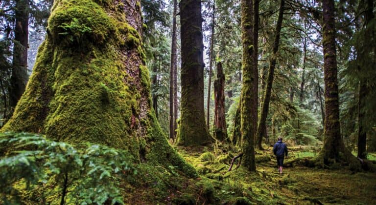
The Cape Fife Trail is well marked and maintained. A trail crew in recent years has made a number of improvements to the hike. As you walk through old growth forest and through some wet boggy areas, there is often a dry or elevated alternative to walking in the muck, using bridges, planks or wood biscuits covered in netting. While most of the planks or biscuits are covered in netting or anti-slip coverings, some of the covering has come off on the older planks and they can be very slippery. I managed not to fall, but had a slip that had me doing the splits about 2 inches shy of a groin injury – you have been warned!
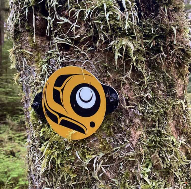
The trail is marked with a combination of orange triangles, yellow reflective arrows, pink or orange flagging tape, the odd buoy and a round yellow, white and black marker featuring a unique Haida Art Design that will give a hiker unwavering faith that they are most definitely on trail. Furthermore, each km is marked and noted. The trail is very well worn, although in a few places, long grass bends over the trail and obscures it from time to time. It is, however, so well marked that during the daytime, at least, it would be very difficult to stray from the path if you were trying to follow it.
Although the trail has very little elevation (approximately 320 meters for the entire 20km return trip), the Cape Fife trail is considered moderate due to its length, some rooty sections, and on at least one occasion, needing to crawl under a log. This is something to consider when assessing your own mobility requirements.
After hiking past great cedars, hemlock, pine, bogs lined with labrador tea, slugs slowly slinking along wooden planks covered in leaves, and up and down a few knolls, at approximately km 7, I could start to hear the sounds of the waves from Hecate Strait on the East side. The trail gradually began a descending pattern and soon, beach grasses figured their way into the landscape. If these external factors were not enough indication that I was drawing near East Beach, I was getting internally signaled as my stomach growled and I also noticed I had already drunk well over half of my water supply (Note: Bring MORE than you think you’ll need). As Reggie drank carelessly from yet another boggy hole, I wondered if I would be desperately tempted to quench my thirst in a stagnant puddle on my return hike.
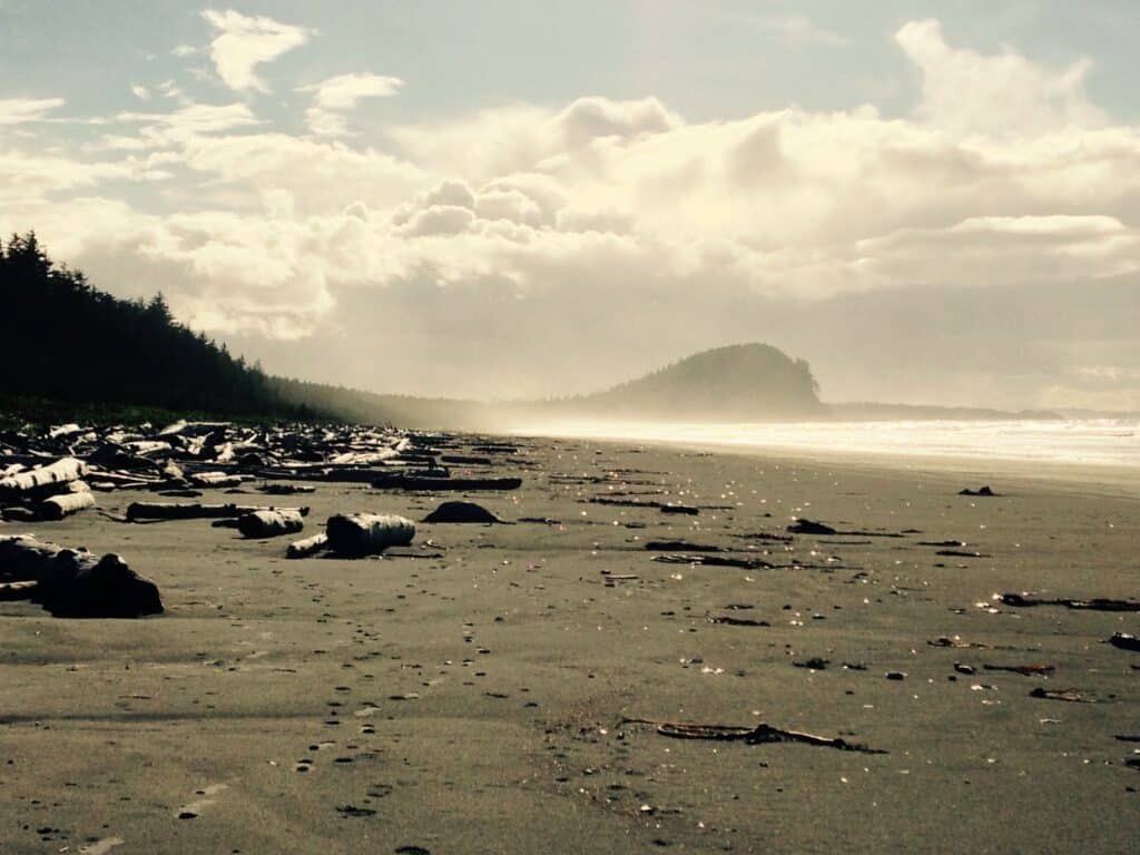
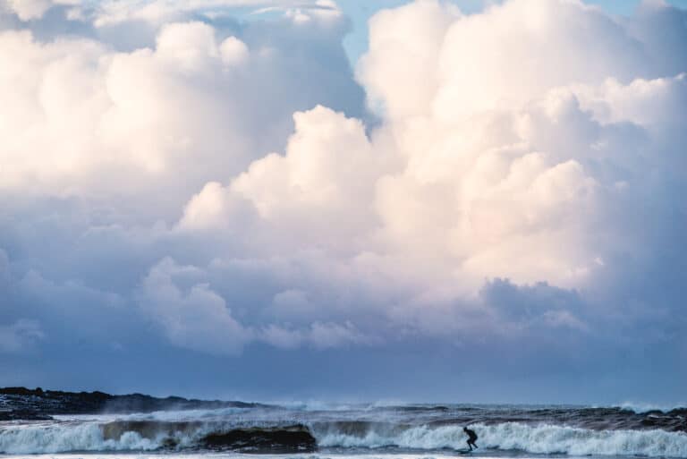
We emerged from the trail amid sand dunes with beach grass all around, and walked straight to the beach, curious to see if the waves were as big and wild as they sounded. The wind was decidedly easterly on this day, and the seas churned and frothed resulting in a wonderful, wild water show. An astute observer might wonder which “Cape” the Cape Fife Trail is referencing, as there appears to be no land feature that meets that description on the beach at the trail’s end. Through years of erosion, the “point” or “cape” that once existed at the end of the trail, is no longer.
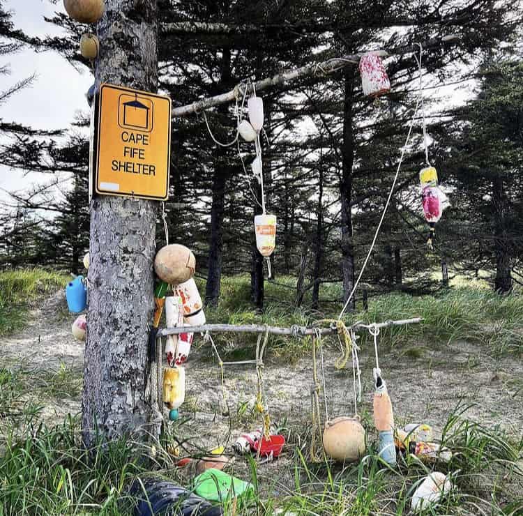
As I stood to watch the ocean in the howling wind, the rain started coming down, and the shelter provided a welcome respite from the weather. The cabin is set back about 50 meters from the beach and is not visible from the shoreline. There are signs adorned with buoys and other beach paraphernalia indicating its location from the beach, in case you are arriving at the shelter or trail from North Beach, or from the longer East Beach hike. The cabin is in great shape and maintained by BC Parks. The cabin itself is about 25 years old, and was built on a joint initiative between the Council of the Haida Nation and BC Parks, and is a wonderful example of local Haida style and craftsmanship. Usage of the cabin is limited to day time visits and for emergency use only, according to the current COVID 19 guidelines. Check in with the local BC Park Rangers at the Naikoon Headquarters in Tlell, or go to the BC Parks website (http://bcparks.ca/explore/parkpgs/naikoon) to find out the current scoop on cabin usage regulations, as they are subject to change.
On this day, I was happy to ride out a small rain shower, sign the guest book, eat some snacks and be on my way back from whence I came. As the sun set somewhere behind the clouds on a grey evening, Reggie and I made it back to the car with tired feet, a wicked thirst that I decided not to quench with bog water, and the satisfaction of a day well spent on Haida Gwaii.
Read more Haida Gwaii adventure stories!
-
An Awakening Hike
Length: ~10km one wayDifficulty: ModerateTiming: ~ 3 hours one way Know before you go: Water sources are sparse on the way to Cape…
-
Dancing with the winds
Length: ~10km one wayDifficulty: ModerateTiming: ~ 3 hours one way Know before you go: Water sources are sparse on the way to Cape…
-
Into the woods
Length: ~10km one wayDifficulty: ModerateTiming: ~ 3 hours one way Know before you go: Water sources are sparse on the way to Cape…
